  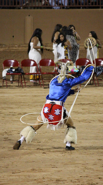
| Gallup Inter-Tribal Ceremony | | The first stop on our trip was Gallup, New Mexico, where they happened to be holding the 92nd annual inter-tribal ceremonial - a combination powwow, rodeo, and arts show involving Native American tribes from across the United States. We attended one of the evening night dances where we got to see Zuni Ollo Maidens dancing with pots balanced on their heads (representing the traditional way women carried pots of water to the pueblos) and a very dynamic hoop dance where the dancer had to swing (and occasionally jump through) multiple hoops. |

| Watch Your Head | | Next stop was the stark volcanic landscapes of the often overlooked El Malpais National Monument near Grants, New Mexico. A highlight of this unique area are the collection of lava tube caves that you can wander through on your own (after picking up a free pass at the visitor center). As lava flows spread across the land, the surface of the flow would cool and harden while the still-molten lava beneath kept flowing - leaving behind these hollowed out drainage tubes. |

| A Very High Highway | | In the 1920s, pilots traveling cross-country still navigated largely by line of sight. To aid long-distance air travel (particularly for the early air mail service), the government designated a number of national air routes including one running through northern New Mexico and Arizona (roughly along the route of modern I-40). To help pilots follow these early highways of the air, they built giant concrete arrows along the routes as well as rotating light beacons (for flying at night). At the Grants airport the local Cibola Historical Society has restored one of the original beacons and the associated generator shed. |
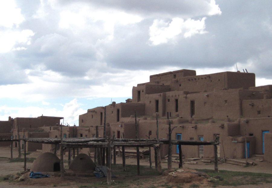
| Ancient Condos | | Nestled at the base of the Sangre de Cristo Mountains northeast of Santa Fe, the small Native American village of Taos Pueblo still appears much as it did hundreds of years ago. The tribe has made a point of retaining the traditional architecture and appearance of the historic pueblo (including no running water or electricity). Something of a living museum, Taos Pueblo is both a National Historic Landmark and a World Heritage Site. |

| St. Jerome Chapel | | As with most of the New Mexico pueblos, the early Spanish missionaries established chapels and churches to convert the inhabitants to Catholicism. The original church at Taos was built in 1619, but was later destroyed during the Mexican-American War. The current St. Jerome Chapel was built in 1850. |

| Ghost Ranch Range | | North of the small pueblo of Abiquiu, US84 runs through a long and empty, but beautiful, stretch of land with brightly colored cliffs and hills on one side and rolling grassy plains on the other. Famous painter Georgia O�Keeffe lived for many years in Abiquiu, but also owned a small cabin at the nearby historic Ghost Ranch where she frequently included elements of this landscape in her work. |

| Closed Cafe - Tierra Amarilla, NM | | There is something haunting about the tiny village of Tierra Amarilla. Even though it is the county seat of Rio Arriba County, half the buildings in town are empty reminders of some past time period. But what time period is unclear. Some have the old west feel of the 1880s, others the 1920s, and others still seem to be from golden age of automobiles in the 1950s. The town does not seem to be from any one time or place - not even from today. To further enhance the odd disconnect of time and place: although the town has no operating hotel, restaurant, or grocery store, it does feature a new (and surprisingly good) gourmet coffee shop called 'The Three Ravens'. |
 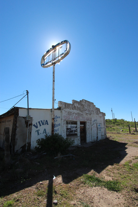
| Ghosts of Tierra Amarilla | | Underneath the almost graveyard-still tranquility of Tierra Amarilla there is a sense of endless stories lurking just beneath the surface. In the 1960s, a local group known as the 'TA Raiders' briefly took over the courthouse in a bid to reclaim ancient land grants. |

| Oratory at Cebolla | | Adding to the slightly mystic feel of the area is the nearby 'Sacred Heart of Jesus Immaculate Heart of Mary Oratory' where a local man has placed bronze depictions of the Stations of the Cross (and related statues) on a peaceful ridge overlooking the small town of Cebolla. |
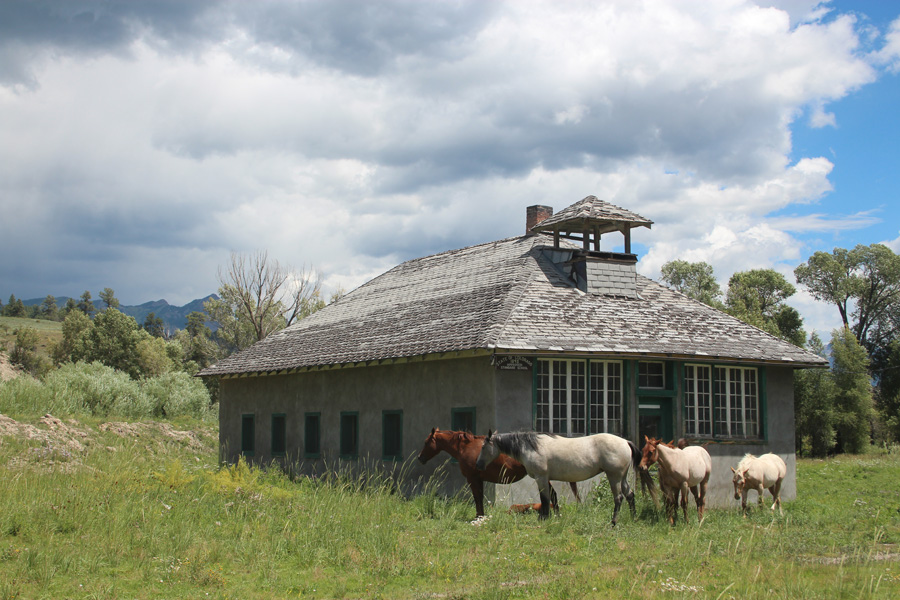
| School's Out | | Crossing the border into Colorado, the first community along Highway 84 is the tiny ranching hamlet of Chromo. At the historic one-room school house, the students were gone for the summer - and probably for the rest of the century too. |
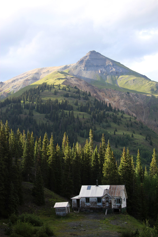
| Red Mountain Blues | | Heading north into the mountains of Colorado along US550, one passes through the historic old mining towns of Durango, Silverton, and Ouray. The ride over Red Mountain Pass is breath-taking both for the amazing mountain scenery and the sheer drops along the edge of the highway (often with no shoulder or guardrail). Just north of the pass are numerous remnants of old mining operations including this empty house near the old Yankee Girl mine. |
 
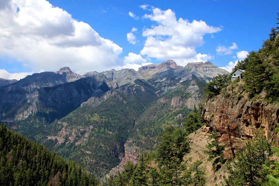
| Upper Cascade Falls | | In Ouray, we hiked up to the large basin overlooking town (known as the 'Amphitheater') and then worked our way along a cliff face to Upper Cascade Falls and the nearby ruins of the Chief Ouray Mine. Starting at an elevation of 8,000 feet and climbing another 2,000 feet, the trail can best be summarized as this: steep, steeper, freak'n scary, beautiful. |
| Hanging in There | | There was not a lot of level ground for construction at the mine site, so the miners wedged their bunk house (right) into the hillside like a swallow's nest. It is actually in a much more precarious location than it appears and sadly will probably not be around for many more years. The town of Ouray is out of sight at the bottom of the canyon. |
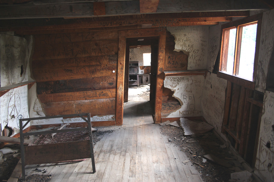
| Leans a little something to be Desired | | Inside the bunk house were several rusted bedframes and an ancient cast-iron stove (as well as ridiculous amounts of not-so-historic graffiti). The entire building is leaning slightly and combined with the 'empty space' views out the windows can be a little disorientating to walk through. Hmm... why did I go in there again? |
 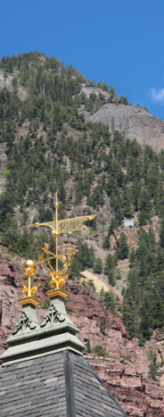
| Hotel and Mine | | After our long hike, we enjoyed a relaxing dip in the famous Ouray hot springs before returning to our room in the recently restored Beaumont Hotel. When it first opened in 1886, the Beaumont was one of the grandest hotels in Colorado and the lodging of choice for the rich and powerful (including several presidents). If you look just to the right of the hotel's wind vane, you can faintly see a grey spot on the mountainside that is one of the buildings at the Chief Ouray mine we visited on our hike. |

| Hovenweep Castle | | After a few days enjoying the tourist luxuries of Ouray and Telluride, we came down out of the mountains and headed west toward Hovenweep National Monument along the Colorado-Utah border. Hovenweep is a collection of prehistoric ruins built by the Ancestral Puebloan people (AKA: Anasazi) around 800 years ago. |
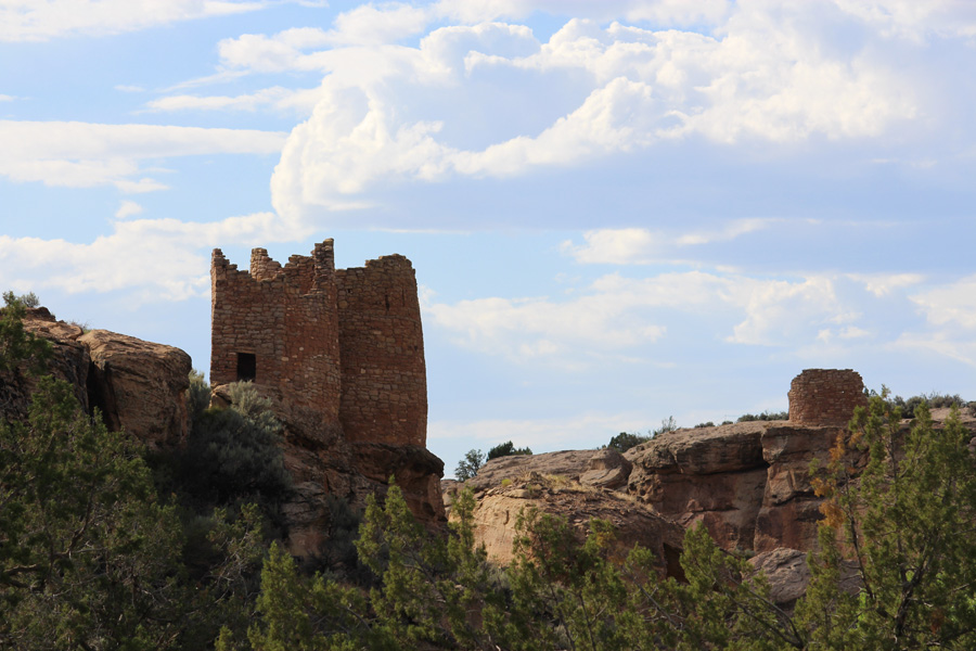
| Twin Towers and Ancient Powers | | Hovenweep is noted for the unusual number of tall, often square, tower-like structures compared to other Ancesteral Puebloan sites. The exact reason for this construction style is unknown although researchers have speculated at both defensive and ceremonial purposes. The communities were abandoned around 1300AD with their descendants migrating southeast to form the modern pueblo tribes. |

| Home on the Rock | | The ruins at Hovenweep consist of numerous small structures built around the edges (and sometimes bottom) of a small rocky canyon like expensive homes around a fishing lake. The pink and red color of the rocks make many of the ruins appear to be in a perpetual sunset while their sometime precarious cliff-side locations can make for dramatic settings. |

| One Heavy Hat | | After a final night in tiny Bluff, Utah, we headed home to Arizona along US163. Dark and dramatic monsoon storm clouds caused the landscape to fluctuate between solemn greys and soft warm reds and pinks as shadow and sunlight wrestled each other throughout the afternoon. Near the San Juan River, the small town of Mexican Hat takes its name from the rock formation that resembles an upside down sombrero. |
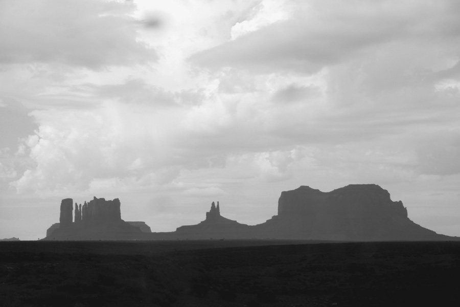
| Monument Grey | | As we approached Monument Valley, the passing storms would occasionally dim the distant monuments to nothing more than silhouettes and then suddenly highlight them in spotlights of warm sunlight. |

| Monsoon Mittens | | I was worried it might be too dark and grey for good shots at the Monument Valley overlook, but the valley rarely disappoints regardless of the weather. Just enough light broke through to bring out the colors and details of this famous landscape. The Navajo Nation runs the valley as a park and has recently opened a large (but surprisingly tasteful) lodge near the overlook and visitor center. |
|

